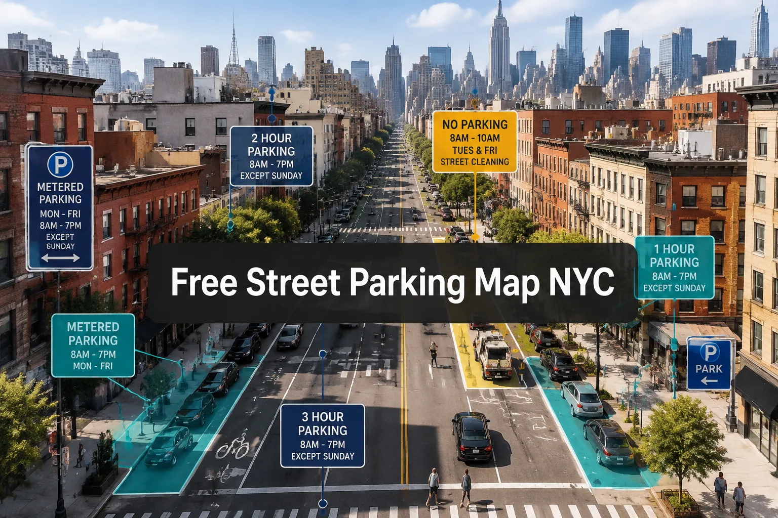
New York City drivers paid over $565 million in parking fines in 2025. Most violations stem from confusion over where and when street parking is actually free. No single official «free street parking map NYC» exists from the city government, but multiple tools now decode the complex web of signs, meters, and Alternate Side Parking rules to reveal thousands of legal, no-cost curb spaces across all five boroughs.
Finding free street parking in NYC requires understanding three moving parts: posted sign regulations, real-time Alternate Side Parking suspensions, and meter enforcement schedules. This guide breaks down the best free street parking map NYC resources, explains how to use official DOT data alongside third-party tools, and shows exactly when and where you can park without paying, or getting ticketed.
Key Takeaways
- NYC DOT’s Parking Regulations Map at nycdotsigns.net is the authoritative source for all street parking signs and rules, but third-party apps like SpotAngels and FreeParkNYC overlay this data into user-friendly free parking maps
- Free street parking is rare in Manhattan’s core (Times Square, Midtown, Upper East/West Sides) where most curbs are metered; residential outer-borough blocks offer the most consistent free options
- Alternate Side Parking and meters are suspended every Sunday citywide, creating predictable weekly free-parking windows on thousands of blocks
- Real-time ASP status via NYC311 Online, the NYC311 app, or @NYCASP is critical because day-of suspensions (snow, holidays) can instantly convert regulated spaces into legal free parking
- Always cross-check any free street parking map NYC tool against physical street signs, posted regulations are the final legal authority
Understanding NYC's Official Parking Data Sources
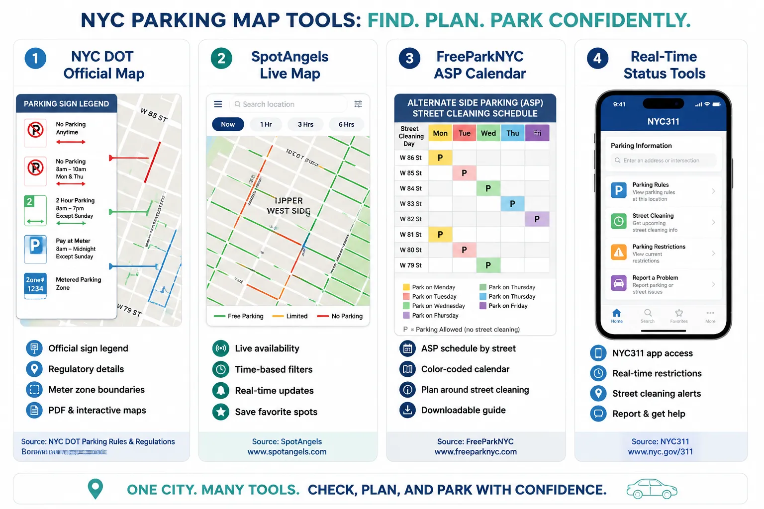
The NYC Department of Transportation maintains the Parking Regulations Map (nycdotsigns.net), which digitizes every parking sign across the city’s 6,300 miles of curb.[13][14] This interactive map displays sign locations, regulation types, and enforcement hours block-by-block. It’s the foundation all third-party free street parking map NYC tools build upon.
How to Use the Official DOT Map:
- Enter your destination address or zoom to your target neighborhood
- Click any curb segment to view active parking regulations
- Review the street sign legend to decode restriction types (meter zones, ASP days, time limits)
- Cross-reference with the official ASP suspension calendar for current-year holidays
The DOT map shows what’s posted, but it doesn’t highlight «free» zones in green or filter by your arrival time. That’s where specialized tools come in.
Official Alternate Side Parking Calendar:
NYC DOT publishes an annual ASP suspension calendar listing every legal and religious holiday when street cleaning rules don’t apply.[9][5] In 2026, ASP is suspended on 32 scheduled dates, plus every Sunday year-round. When ASP is suspended but meters remain in effect, only non-metered residential blocks become free, a crucial distinction many drivers miss.
Check real-time status daily via:
- NYC311 Online or the NYC311 mobile app
- @NYCASP on social media for same-day announcements
- Park Rules Live’s live ASP status tracker for instant updates
Snow operations frequently trigger multi-day ASP suspensions. In early 2026, NYC suspended ASP from January 31 through February 3, extended it February 8-10, again February 11-12 (snow plus Lincoln’s Birthday), February 12-14 and 16-18 (Presidents’ Day, Lunar New Year, Losar, Ash Wednesday), and February 23 through March 3 (Purim).[2][4][6][8][10] Meters stayed in effect during all these suspensions, so true free parking only expanded on unmetered blocks.[2][4][6][8][10]
Best Free Street Parking Map NYC Tools for 2026
SpotAngels NYC Free Parking Map
SpotAngels publishes a continuously updated 2026 NYC Free Parking Map that overlays parking rules on a live, color-coded map.[1] Free spots appear in green, metered zones in red, and time-restricted areas in yellow. The tool was last refreshed August 22, 2026, making it one of the most current citywide resources.[1]
Key Features:
- Time-based filtering: Enter your location, arrival time, and parking duration to see available spots and prices
- Neighborhood coverage: Detailed maps for all five boroughs, with granular data for high-demand areas like the Upper East Side, Upper West Side, Downtown Brooklyn, and Astoria
- Off-peak insights: Identifies blocks that are metered during business hours but free evenings, nights, and Sundays
SpotAngels emphasizes that free on-street parking in Manhattan’s core (Times Square, Hudson Yards, Midtown) is extremely limited.[1] Most curb spaces are metered 8 AM, 10 PM Monday, Saturday, with only scattered free windows late at night or on Sundays. For consistent free options, focus on residential neighborhoods in the Bronx, Queens, Brooklyn, and Staten Island.
Explore borough-specific parking resources:
- Parking in Bronx, NYC
- Parking in Queens, NYC
- Parking in Brooklyn, NYC
- Parking in Manhattan, NYC
- Parking in Staten Island, NYC
FreeParkNYC Maps
FreeParkNYC offers two specialized tools:[3]
- NYC Parking Map: Color-coded display showing where and when street parking is allowed, with filters for time of day and day of week
- ASP Map: Dedicated visualization of alternate-side street cleaning schedules, helping drivers identify legal free-parking windows by matching their parking times to non-restricted periods
Both maps use official DOT sign data but present it in a simplified, scannable format. The ASP map is particularly useful for understanding complex multi-day cleaning schedules in dense neighborhoods.
How to Maximize Free Parking with FreeParkNYC:
- Select your target neighborhood and intended parking duration
- Use the ASP map to find blocks where cleaning occurs on days you won’t be parked
- Verify that the block has no meters (check the NYC Parking Map or physical signs)
- Confirm same-day ASP status via NYC311 before leaving your vehicle
NYC DOT Parking Regulations Map & Sign Legend
For absolute accuracy, always cross-reference third-party maps with the official DOT Parking Regulations Map.[13][14] Posted street signs are the final legal authority. If a free street parking map NYC tool shows a green «free» zone but the physical sign says «No Standing 8 AM, 6 PM,» the sign wins.
Critical Sign-Reading Tips:
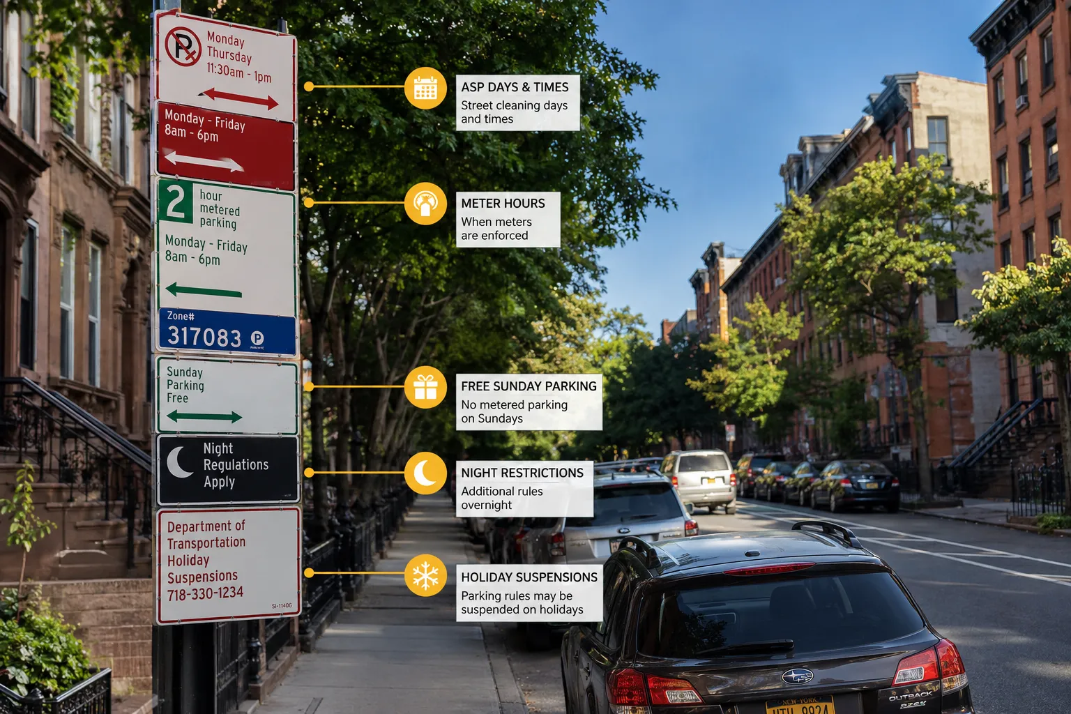
- «No Standing Except Trucks Loading/Unloading» means passenger cars cannot park, even if a map shows the block as unrestricted
- Meter hoods or bagged meters do not automatically make a space free, check for temporary «No Parking» signs
- Overlapping regulations (e.g., ASP + meter + 2-hour limit) all apply simultaneously; you must satisfy every restriction
Learn to decode complex sign combinations in our guide to Alternate Side Parking rules in NYC.
Where Free Street Parking Actually Exists in NYC
Manhattan:
Free curb parking in Manhattan is concentrated in upper residential neighborhoods (Washington Heights, Inwood, East Harlem) and becomes available evenings/nights in the Lower East Side and parts of the West Village. Midtown, the Financial District, and the Upper East/West Side cores are almost entirely metered.[1]
Brooklyn:
Outer Brooklyn neighborhoods, Bensonhurst, Bay Ridge, Sheepshead Bay, Canarsie, offer extensive free residential parking with standard ASP rules. Williamsburg, DUMBO, Park Slope, and Downtown Brooklyn are heavily metered, with free options limited to side streets during off-peak hours.[1]
Queens:
Queens has the most abundant free street parking citywide. Flushing, Astoria (away from the waterfront), Jackson Heights, Forest Hills, and eastern neighborhoods like Bayside and Bellerose feature thousands of unmetered residential blocks. Check ASP schedules carefully, many blocks alternate Monday/Thursday and Tuesday/Friday.[1]
Discover neighborhood parking options:
Bronx:
The Bronx offers widespread free parking in residential areas like Pelham Bay, Morris Park, Fordham, and Riverdale. Commercial corridors (Fordham Road, Grand Concourse) have meters, but side streets one block away are typically free with ASP.[1]
Browse Bronx parking facilities:
Staten Island:
Staten Island has the least restrictive parking in NYC. Most residential streets are free with minimal or no ASP. Metered zones exist only in commercial centers like St. George and along the North Shore near the ferry terminal.[1]
Explore Staten Island options:
Avoiding Fines and Towing: Real-Time Status is Essential
Even the best free street parking map NYC tool can’t prevent tickets if you ignore real-time updates. ASP suspensions, snow emergencies, and special events change parking rules daily.
Critical Real-Time Resources:
- NYC311 Online & App: Official same-day ASP status, updated by 6 AM each morning[7][9]
- @NYCASP: Social media alerts for suspensions and enforcement changes
- Park Rules Live ASP Tracker: Instant status for NYC and surrounding cities like Yonkers, Mount Vernon, and Buffalo
2026 ASP Suspension Pattern:
NYC suspended ASP for 17 days between January 31 and March 3, 2026, due to snow operations and holidays.[2][4][6][8][10][11][12] However, meters remained in effect during nearly all these suspensions, meaning drivers on metered blocks still had to pay. Only unmetered residential streets gained true free parking during these windows.
Fighting Unfair Parking Citations:
If you receive a ticket despite parking legally during a suspension or in a properly signed free zone, use the NYC Parking Education Hub resources:
- How to Fight a Double Parking Ticket in NYC
- Tickets & Disputes guides for contesting unfair citations
Document the street signs, suspension notices, and your vehicle’s position with timestamped photos. Challenge tickets online via NYC DOT’s hearing system within 30 days.
Conclusion
Finding free street parking in NYC demands more than a static map. Combine official DOT data from the Parking Regulations Map with real-time ASP status from NYC311 and user-friendly tools like SpotAngels and FreeParkNYC. Focus your search on residential outer-borough neighborhoods, leverage Sunday’s citywide meter and ASP suspension, and always verify physical street signs before walking away from your vehicle.
Action Steps:
- Bookmark the NYC DOT Parking Regulations Map and the 2026 ASP suspension calendar
- Download SpotAngels or FreeParkNYC to filter free zones by time and location
- Check NYC311 or @NYCASP every morning for same-day ASP status
- Photograph street signs and your parking spot to document compliance
- Explore off-street alternatives during high-demand periods via the NYC Parking Directory
Avoid fines and towing by staying informed. Use these free street parking map NYC tools together, not in isolation, to navigate the city’s complex curb regulations and keep your vehicle legal, safe, and ticket-free in 2026.
References
[1] Nyc Free Parking Map – https://www.spotangels.com/blog/nyc-free-parking-map/
[2] Suspension Of Alternate Side Parking Regulations Feb 23 26 – https://www.nyc.gov/html/dot/html/pr2026/suspension-of-alternate-side-parking-regulations-feb-23-26.shtml
[3] freeparknyc – https://www.freeparknyc.com/
[4] Suspension Of Alternate Side Parking Regulations Jan 31 26 – https://www.nyc.gov/html/dot/html/pr2026/suspension-of-alternate-side-parking-regulations-jan-31-26.shtml
[5] Nyc Parking Calendar – https://www.assembly.state.ny.us/write/upload/req/nyc_parking_calendar.pdf?v=1778692896
[6] Suspension Of Alternate Side Parking Regulations Feb 11 26 – https://www.nyc.gov/html/dot/html/pr2026/suspension-of-alternate-side-parking-regulations-feb-11-26.shtml
[7] Alternate Side Parking – https://www.nyc.gov/html/dot/html/motorist/alternate-side-parking.shtml
[8] Suspension Of Alternate Side Parking Regulations Feb 12 26 – https://www.nyc.gov/html/dot/html/pr2026/suspension-of-alternate-side-parking-regulations-feb-12-26.shtml
[9] Asp Calendar 2026 – https://www.nyc.gov/html/dot/downloads/pdf/asp-calendar-2026.pdf
[10] Suspension Of Alternate Side Parking Regulations Feb 8 26 – https://www.nyc.gov/html/dot/html/pr2026/suspension-of-alternate-side-parking-regulations-feb-8-26.shtml